Stage 2 Rawlins - Del Norte
 |
Stage 2 Map
|
 |
| Stage 2 Elevation |
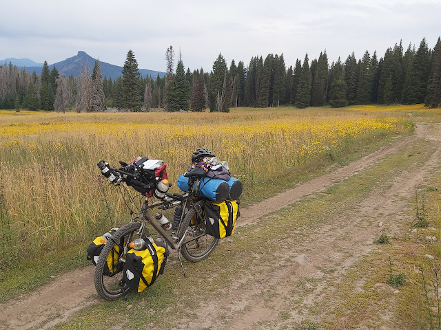
Getting closer to Colorado, the landscape was starting to change. The grasslands slowly gave way to trees and bushes. This was a welcomed sight, as it was a lot more pleasant on the eyes and the shade became less of a commodity.
 |
| Landscape Change |
Hiding the campsite is much easier now with all the tree growth as well.
 |
| 1st. Camp in Colorado |
Forest Road 42 toward Meaden Peak is rocky, rough and steep with up to 13% inclines. Sure glad I left the extra weight behind in Rawlins, as I barely could push the bike up those grades. The almost 9900 feet altitude didn't help the breathing either.
Spent almost 2 hours to cover the last 1.5 miles, pushing, huffing & puffing 😱
 |
| FR 42, Rough Going |
 |
| Lovely Meadow |
 |
| More Rough Going |
Going over the top was a great relief, even as the bike still had to be walked downhill, because of the rocky road.
 |
| Slightly Over 9851 feet |
 |
| Easier Going Downhill |
Wild and domestic creatures.
 |
Moose Crossing
|
 |
| Size has right of way |
Afternoon downpours turned into an all day rain in Steamboat Springs, which was excellent timing to take a day off. As it is a Ski town, tourists flock here in the summertime as well and this calls for establishments such as coffee shops and of course a brewery, where time is spent tasting local specialties...
 |
| Local Specialties To Be Had |
 |
| Bike Path Out Of Town |
A pleasantly paved road was leading out of Steamboat, then eventually turned into gravel as usual. The journey to Lynx Pass .....
 |
| Road to Lynx Pass |
 |
| Was Able To Skip The Work!! |
 |
| Lynx Pass Camp |
After Leaving camp, the trail quickly turned into rocky climbs and descents. On one of those downhills, a hungry rock took a bite out of the rear tire and rendered it useless. After a tire & tube change the trail continued down to the Colorado River in Radium.
 |
| River Crossing |
 |
| Colorado River Valley View |
 |
| Road to Radium Tire Change |
 |
| Tire Damage |
 |
| Colorado River |
 |
| Looking Back at Approaching Clouds |
 |
| A More Tame Colorado River Upstream |
Every day in this adventure brings a variety of road conditions, sceneries and levels of riding efforts. Being in Colorado and the Rockies, a Mountain Pass crossing is almost a daily occurrence. Ute Pass with an elevation of 9524 feet, a 4.5 mile 7-8% grade was no exception.
 |
| Top of Ute Pass |
Frisco was another town calling for a rest day. Now it was the challenge of finding a new tire. 20 years ago, (age of my bike) 26 inch wheels were the most common size, with parts readily available. Times have changed with 27.5 & 29 inch wheels now being hip. Bicycle shop #3 finally had my tire size and without any selections, at least I had a spare again!
 |
| Dillon Reservoir |
Leaving Frisco started with a pleasant ride on a bike path to Breckenridge. There started the ascent to Boreas Pass of 11482 feet, the second highest of this trip. As the dirt road follows the former narrow gauge railroad that connected Breckenridge with Como, the outside world in those days (1872-1938), the grade was an easy 3-4%.
 |
| Bottom of Boreas Pass |
 |
| Breckenridge Ski Runs |
 |
| Railway Lines Got Replaced With A Dirt Road |
 |
| Water Tank For Thirsty Steam Engines |
 |
| Top of Pass 😌 |
Afternoon rains continued and camping after Boreas Pass was rather unpleasant. At almost 10000 feet in elevation, the camping experience took a new low. Wet, damp and cold!
A bicycle tour group from the "Adventure Cycling Association" also made their home in that environmental unfriendly place. As they are supported by a vehicle, they are better equipped with shelter, kitchen etc. This was to my advantage though, with extra dinner to go around. I just had to get in line with my plate to get fed and the following morning, coffee was served just the same way. Thank You ACA...
 |
Food Storage to Keep Bears Out
|
 |
| Wet Campsite, Was Like Sleeping on a Waterbed!! |
 |
| ACA Support Van |
Riding continued through South Park:
South Park is a high altitude (9'000 to 10'000) grassland valley with nice rolling hills. The rains subsided, blue skies reappeared and as well got rewarded with a lovely tailwind 😊
 |
| Heading Down to South Park |
 |
| Relaxed Riding Through South Park |
Not before long another pass was waiting to be conquered. Marshall Pass was also an old railway line connecting Denver with Salt Lake City. At 10842 feet, the 3-4% grade made it for a comfortable ascend, although the almost 20 miles uphill took several hours...
 |
| Going up Marshall Pass |
 |
| Ticking Off Another Pass |
All this hard work called for a special dinner: An instantly served 5 course meal... 😋
 |
| 5 Course Meal... 1st. Course is Ready |
The mountain passes kept on coming: Cochetopa pass at 10067 feet. (named by the Ute Indians meaning Buffalo Pass)
 |
| Riding up to Cochetopa Pass |
 |
| One of Many Lovely Campsites |
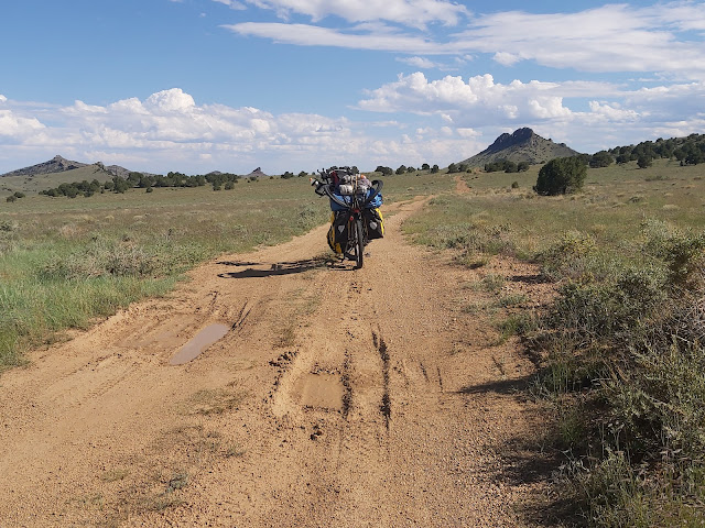
Next up: Carnero pass of 10166 feet, leading down to the San Luis Valley a high altitude basin and the headwaters of the Rio Grande.
 |
| Carnero Pass |
 |
| Riding Into the San Luis Valley |
 |
| San Luis Valley |
Riding the back roads into Del Norte was rather rough. If I only knew what was to come!!
 |
| It's Called Natural Arch, But Looks Like A Hole In A Rock Wall |
 |
| Rough Going to Del Norte |
 |
| Crossing the Rio Grande Into Del Norte |
Colorado is becoming a more & more likeable State... every little town, no matter how small, seems to have a local brewery!
B & B'c are now my local favorites. (Brewery & Bakery Cafe)
 |
| Three Barrel Brewery |
 |
Bad Phil Appears To Be the Favorite 😋
|
 |
| Favorite Morning Establishment |
Stage 3 to follow from further Down the Road...


